The weather threw almost everything it had at us last month! Here’s the Kernow Weather Team with their lengthy January summary.
What a month it has been, I think we counted around thirteen Met office warnings.
We started the new year with the first Met Office yellow weather warning for wind. Strong winds hampered New Year celebrations, with the 1st of January turned out to be a very soggy one. This also brought the first chill to the year and a number of flood alerts across the county.
Once a cold front swept through, an amber weather alert was issued by the UK health security agency for a spell of prolonged cold. After such mild temperatures a sudden drop to 0°C to 2°C left everyone shivering, with the risk of overnight frost. There were even reports of snow in some areas. We issued our own weather advisory for wind and wind chill as a low moved up from the southwest, so a mixture of rain and snow was in our forecast, then once the low swept through much colder air was to follow.
By the 5th, another yellow weather warning for rain was issued. This kept the page busy with multiple radars.
The airmass changed back to a mild tropical which brought our normal rain, mist and fog, several airmasses had our temperatures in swing mode from mild to freezing in a flick of a switch, it certainly gave us a headache, especially with another low pressure heading in. Another met office warning for snow and ice was issued on the 6th, which brought the next few days a nice wintry mix along with cold northwesterly winds. A low which was pushing in from the Southwest was expected to bump into the cold air bringing a varied precipitation.
By the 8th January another yellow weather warning for snow was issued. It rained in some parts of West Cornwall, but boy did it snow in mid Cornwall.
The A30 had its normal problems with cars stranded around Jamaica Inn, leading to roads being closed. We had a right old mixture, which led to an amber warning for snow across mid Cornwall and snow and ice elsewhere. What a day that was along with multiple weather warnings infact its only the 9th of January I’d already lost count.
From the 10th, the weather calmed down, we had our normal episodes of mizzle, rain, mist, and fog, which brought poor visibility. Into the second week of January the anticyclonic gloom was back as we said bye bye cold, hello milder air and high-pressure. The problem was our daily forecasts became boring, we were writing the same everyday. At one point temperatures reached up to 14°C, but unfortunately there wasn’t an awful lot of sunshine to be had. Most days the skies were laden with cloud, mist and fog.
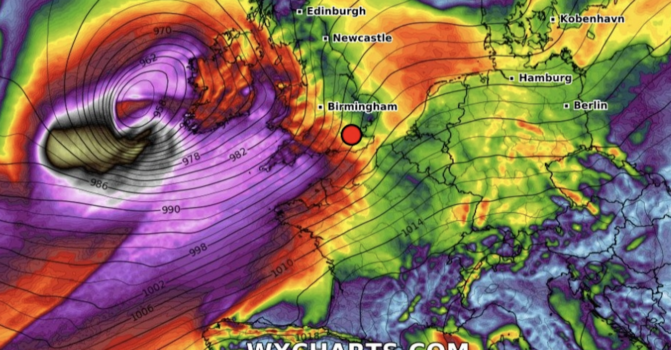
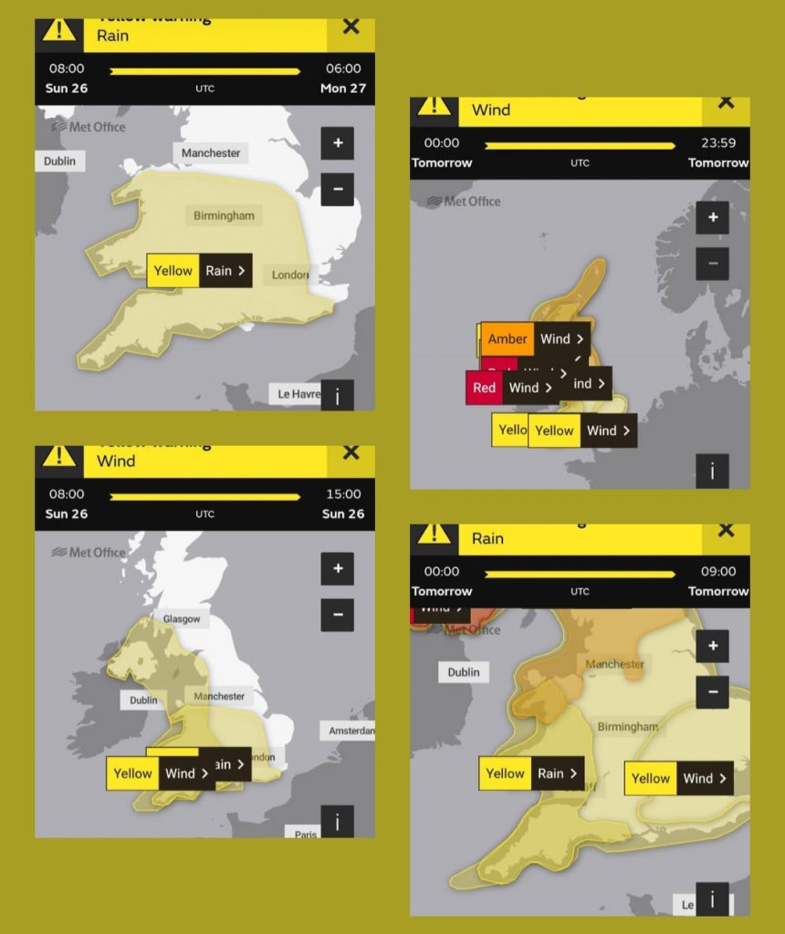
As we head into the 3rd week of January, big changes were afoot and we issued our own weather watch, as the Atlantic swung into full force by throwing a series of lows our way. A northerly airmass over North America helped to intensify the jetstream, which had the UKs name on it. Many weather models were throwing out bizarre scenarios that had us here at KWT scratching our heads in disbelief. Eventually, Storm E’owyn was named by the Met office. This became a very powerful storm for Ireland. With another yellow weather warning for us for strong winds issued ahead of the storm.
As Storm E’owyn developed, it prompted the NOAA42 Hurricane Hunters to be deployed, operating out of Shannon Airport to gather data. This was to become such a vicious storm, which underwent explosive cyclogenis and brought wind speeds over over 100mph to Ireland. Thankfully here in Cornwall wind gusts only exceeded 80+mph, and to be perfectly honest feel we definitely dogged a bullet with this storm. However we didn’t get off lightly, as another yellow weather warning for strong winds and rain was issued on the 22nd of January.
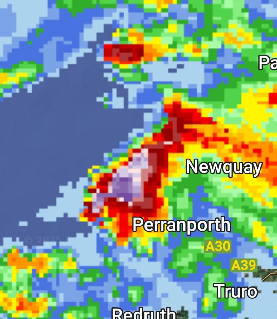
It was during this small period of crazy weather on the 23rd that Quintrell Downs in Newquay was struck by a mini tornado. This travelled across parts of Newquay and was seen as far away as Bodmin. Homes had their roofs ripped off, there was tiles and debris everywhere. Sadly a holiday park in Newquay got ripped apart, leaving caravans upside down and severely damaged. It looks like a funnel cloud developed out at sea, then picked up an injection of warmer air inland producing this tornado, which went viral across many news outlets. This was only spotted on radar as a large cell as it was rain wrapped, so no indications of hook echoes or rotation were seen.
After this two more Met office weather warnings were issued, and a third for ice.
By the 24th came Storm Herminia, issued by the Spanish meteorological service. This storm had the worst effects over Spain, but because of its direction it was felt widely across Cornwall. With the storm bringing wind gusts exceeding 80mph, torrential rain and further damage to properties, fallen trees, power cuts, and lose debris.
Another two weather warnings were issued (including the Met office changing the times) for the following Monday. Storm Herminia wasn’t finished with us yet and was slow moving.
Just as we thought the weather was calming down, along came a nice thunderstorm the early hours of the 27th of January. This storm started around 2am and brought hail, thunder, lightning, vicious winds and downbursts, which proceeded to wake most of the west of Cornwall.
So we have had a multitude of storms, warnings, rainfall, winds and power cuts this month. At least in the last few days of January a ridge of high-pressure built, bringing calm conditions and sunshine.