Where the Hag of Winter Washed Her Plaid
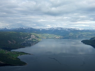
 Between the islands of Jura and Scarba in the Hebrides lies the whirlpool of Corryvreckan. It is the third largest whirlpool in the world, only surpassed by the Moskstraumen and the Saltstraumen, both of which are in Norway. Corryvreckan is formed by the tide in the Sound of Jura being compressed in the gap between the island and the mainland. As it gains speed it reaches the Gulf of Corryvreckan with Jura to the south and Scarba to the north. The tide then pours through this gap. In the Gulf itself the sea bed is very uneven and the water depth varies between 250 and 450 feet.
A little way in there is a huge hole in the seabed, over 700 feet deep, which is twice the height of St Paul’s Cathedral. The water pours into this hole and then on down the Gulf where it is confronted by a high pinnacle of rock. This pinnacle is about 200ft high and rises to within about 90ft of the surface. The effect is to form a massive whirlpool, a vortex with its centre many feet below the surrounding sea, and waves which can be 15ft high. With a gale in the right direction and a spring tide the roar of the race can be heard 15 miles away.
 The whole area is surrounded by hills, often their tops covered in clouds. In Scots mythology, as winter approaches these clouds are the plaid of the Hag of Winter. The goddess, or witch, depending on the version being told, lives in the mountain tops and comes to Corryvreckan to wash her plaid, which is the clouds. She takes three days to do this and then spreads it out over the land which turns white with snow. The other name for the Hag is Cailleach which means,in Gaelic, the hooded or veiled one. When Christianity came to Scotland this became the Gaelic word for a nun because of their whimple, thus the oddity of the name for a heathen spirit being applied to a holy Christian woman.
Despite its dangers Corryvreckan is not unnavigable. It was in fact surveyed for soundings in 1748 by Murdoch Mackenzie, a hydrographer employed by the Admiralty, and it is a testimony to the seamanship of the day that it was done in a small eight oared boat.
Probably the world’s fastest tidal current is the Saltstraumem where the stream can reach 20 knots. This is because the tide of the North Sea is trying to fill Skjerstad Fiord through a channel which is about two miles long but only 150 yards wide. The tide rises on the sea side faster than it rises in the fjord so there can be a ten foot high wall of water trying to enter the fjord. The Moskstraumen is a bit different as it is in more open water but it is still bigger than Corryvreckan. It is caused by the fact that the tide is passing over exceptionally rough sea bed.
 I have told the tale to illustrate the effect that the land has on the tide. Out in the ocean there is no tide to speak of. The water moves in currents, the Gulf Stream, the Humbolt and these, it is believed, can affect our weather. But as you approach land the tidal effect increases and you get the approximately six hour periods of rise and fall that we see. If the coastline is open, as it is in front of our Lookout, then the tide flows back and forth with little or no obstruction and the rise and fall is 10 to 15 feet.
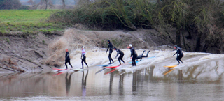
However if you constrict the tide by making it run up a narrowing gap between lands then, as it has business done in six hours, so it speeds up and the volume of water at any particular point increases. The world’s highest tides are in the Bay of Fundy in Canada, but the Bristol Channel comes a close second. Down here we consider we have a big tide if it is 5.5 metres (18ft in old English). At Weston-super-Mare the tide has reached 14.5 metres or 48ft! This pressure of water then tries to run up the ever narrowing estuary of the Severn producing the tidal bore, an inland tsunami, a wave in the centre of the river which may be 9ft high, travelling at 12 to 13 miles per hour, attracting surfers from worldwide.
 But to return to the tide as it affects us in front of the Lookout. When the tidal flow passes up a straight coastline the water goes without hindrance from point A to point B. If you introduce a headland, in our case Nare Head, the effect is similar to cutting cheese with a cheese scraper. A thin sliver of water is cut off and forced back from the tip of the headland, following the line of rocks, then Carne Beach, then Pendower, continuing its journey until it returns to the main tide off Greeb Point.
So Veryan Bay has a contra circulating current going the opposite way to the tide. It is, however, so weak that it forgets where it is going from time to time and wanders about erratically. No one in the Lookout can say in what direction the water is travelling, only that it will be moving very slowly. For us the overriding influence on any object in the water of the inner bay is wind, something Watchkeepers are taught to take into account when plotting drift.
The bigger the headland the bigger the counter current. Dodman takes a much larger slice than Nare hence the counter flow at Dodman is stronger. When you look at places like Portland Bill then there are even Tidal Charts plotting the state of flow at different times. Here, of course, there is the additional problem of outlying underwater rocks causing turbulence as the tide is forced over them, creating a tide race. Thankfully we do not have anything like this in our area, the nearest approach to this being the Bizzies, an underwater ledge about a mile off Greeb Point.
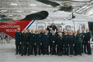 We teach our Watchkeepers all about the tides as part of their training. The rest involves use of the radio, how to use the chart and plot position and seemingly obvious things like use of telephone. If there is an emergency and you have to call the Coastguard or dial ‘999’ you need to be able to get your message across as briefly as possible but, above all, accurately. Ask any Police operator on the receiving end of a ‘999’ call who is the most difficult person to deal with and he will say something like, ‘The person who does not realise that I cannot see what he can see!’
Our training is aimed at three things – you know how to see, you understand what you see and you know how to tell someone else what you see. If you join between April and October when the Lookout is open we aim to get you trained during that summer. This assumes that, during your first six weeks, you can manage to get to two training sessions on Tuesdays at the Lookout and also do at least two watches when you will be paired with an experienced
Our big problem is filling our watch bill every day except Tuesday during the summer months. We are working towards a full 7 day week programme but can never seem to quite make it. One reason is that many of our team are retired and getting older. Though there is no age limit everyone gets to the point when they feel that they have done enough and that the cliff walk down to the Lookout is becoming too much.
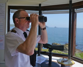 We lose a few members each year because of this and this is balanced by new recruits – but we never seem to reach the state when we can manage seven days a week. We expect all qualified Watchkeepers to do two watches per month, that is 14 in any season. Many do more but that is because their individual circumstances allow. So it is a commitment that you will undertake and we make no secret of that. You will be, however, part of the Emergency Service doing a worthwhile job which may someday save someone’s life.
You can get immense satisfaction out of a successful incident even if it is only telephoning the Coastguard to say that a RHIB has stopped moving and may be in difficulties. Sure, he’s only run out of petrol on a calm day but when you see the Inshore Boat appear and go along side you can say to yourself, ‘I did that’.Watchkeeper. To do a complete training course most people need to do 10 – 12 watches.
If you would like to find out more give Sue a ring on 01872-530500 or Chris on 01326-270681. You can talk it through, perhaps meet, and you can decide if you can give the necessary time to this very worthwhile cause.

